


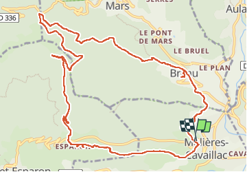
Moulière, Col de Mouzoulès Esparon

JMJ42
User

Length
15 km

Max alt
813 m

Uphill gradient
658 m
Km-Effort
24 km

Min alt
291 m

Downhill gradient
658 m
Boucle
Yes
Creation date :
2022-06-07 07:40:04.971
Updated on :
2022-06-07 13:17:36.99
4h10
Difficulty : Difficult

FREE GPS app for hiking
 SityTrail
IGN / Geographical institutes
SityTrail Plus
The world is yours!
About
Trail Walking of 15 km to be discovered at Occitania, Gard, Molières-Cavaillac. This trail is proposed by JMJ42.
Positioning
Country:
France
Region :
Occitania
Department/Province :
Gard
Municipality :
Molières-Cavaillac
Location:
Unknown
Start:(Dec)
Start:(UTM)
546150 ; 4869435 (31T) N.
Comments