Trail Mountain bike Lavoine - 2022-06-08_08h37m50 - Photo
 ludol
ludol

User

© OpenStreetMap contributors
Length
Length
50 km
Max alt
Max alt
1286 m
Uphill gradient
Uphill gradient
1579 m
Km-Effort
Km-Effort  
71 km
Min alt
Min alt
631 m
Downhill gradient
Downhill gradient
1580 m
Boucle
Boucle
Yes
Creation date :
2022-06-08 06:37:50.876
Updated on :
2022-06-08 07:22:10.507

(0 Reviews)

Mountain bike
Mountain bike
4h56
Difficulty : Very difficult

Scan this QR Code to open this trail in the SityTrail application

FREE GPS app for hiking

Logo SityTrail SityTrail

IGN / Geographical institutes

Download SityTrail from the App Store Download SityTrail from Google Play

Logo SityTrail SityTrail World

The world is yours!

Download SityTrail from the App Store Download SityTrail from Google Play Download SityTrail on Huawei AppGallery

About

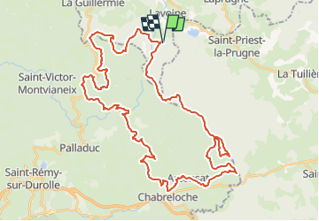
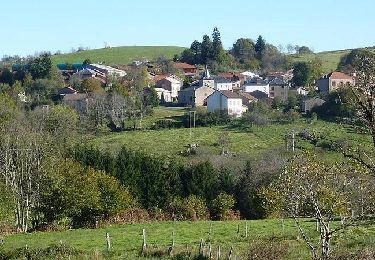
Trail Mountain bike of 50 km to be discovered at Auvergne-Rhône-Alpes, Allier, Lavoine. This trail is proposed by ludol.

Description

Tracé réalisé par un copain, nous le découvrirons le 11/06/2022...

Elevation profile

Positioning

Country:
France
Region :
Auvergne-Rhône-Alpes
Department/Province :
Allier
Municipality :
Lavoine
Location:
Unknown
Start:(UTM)
553806 ; 5090046 (31T) N.

Trails nearby

Trail On foot Saint-Victor-Montvianeix - Margault, la truite Fario - Photo
On foot
PRO

On foot

Easy
Saint-Victor-Montvianeix, Auvergne-Rhône-Alpes, Puy-de-Dôme, France
6.9 km | 9.4 km-effort
2h 8min
Yes
Trail On foot Lavoine - Le Puy de Montoncel - Photo
On foot
PRO

On foot

Easy
Lavoine, Auvergne-Rhône-Alpes, Allier, France
12.5 km | 19.7 km-effort
4h 28min
Yes
Trail Walking Saint-Priest-la-Prugne - Randonnée au dessus de St Priest la Prugne  - Photo
Walking
dudu42

Walking

Medium
Saint-Priest-la-Prugne, Auvergne-Rhône-Alpes, Loire, France
10.9 km | 15.8 km-effort
3h 21min
Yes
Trail Walking Arconsat - Col de la Charme  - Photo
Walking
dudu42

Walking

Medium
Arconsat, Auvergne-Rhône-Alpes, Puy-de-Dôme, France
12.9 km | 16.2 km-effort
3h 36min
Yes
Trail Walking Lavoine - Les sources de la Besbre - Photo
Walking
Bobol

Walking

Medium
Lavoine, Auvergne-Rhône-Alpes, Allier, France
8.4 km | 11.6 km-effort
42h 44min
Yes
Trail Walking Lavoine - De Lavoine à St Clément  - Photo
Walking
NANE51

Walking

Easy
Lavoine, Auvergne-Rhône-Alpes, Allier, France
14.4 km | 19.4 km-effort
4h 1min
No
Trail Mountain bike La Guillermie - Les Moulins au creux des vallées du Terrasson et du Theux - La Guillermie - Photo
Mountain bike
tracegps

Mountain bike

Very difficult
La Guillermie, Auvergne-Rhône-Alpes, Allier, France
42 km | 61 km-effort
4h 15min
Yes
Trail Mountain bike Lavoine - VTT au pied des 8 éoliennes du Chemin de la Ligue - Lavoine - Photo
Mountain bike
tracegps

Mountain bike

Very difficult
Lavoine, Auvergne-Rhône-Alpes, Allier, France
42 km | 58 km-effort
4h 15min
Yes
Trail Walking Lavoine - Lavoine - Le Rocher Saint Vincent et le Roc des Gabelous - Photo
Walking
tracegps

Walking

Difficult
Lavoine, Auvergne-Rhône-Alpes, Allier, France
10.8 km | 15.3 km-effort
2h 30min
Yes


Close
My subscriptions