


col des Grêles

PatriceCocuaud
User
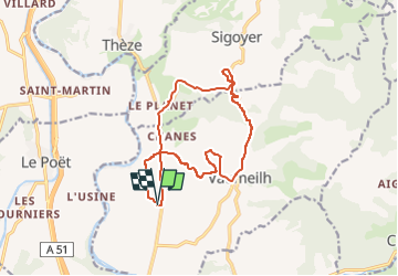

Length
14.5 km

Max alt
735 m

Uphill gradient
288 m
Km-Effort
18.4 km

Min alt
523 m

Downhill gradient
289 m
Boucle
Yes
Creation date :
2022-06-08 15:54:02.934
Updated on :
2022-06-08 16:58:09.427
1h03
Difficulty : Easy

FREE GPS app for hiking
 SityTrail
IGN / Geographical institutes
SityTrail Plus
The world is yours!
About
Trail Mountain bike of 14.5 km to be discovered at Provence-Alpes-Côte d'Azur, Alpes-de-Haute-Provence, Vaumeilh. This trail is proposed by PatriceCocuaud.
Positioning
Country:
France
Region :
Provence-Alpes-Côte d'Azur
Department/Province :
Alpes-de-Haute-Provence
Municipality :
Vaumeilh
Location:
Unknown
Start:(Dec)
Start:(UTM)
734029 ; 4907409 (31T) N.
Comments