


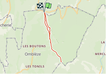
P-Tete-de-la-Dame-Col-de-la-Bataille

guy77340
User

Length
10.5 km

Max alt
1501 m

Uphill gradient
390 m
Km-Effort
15.7 km

Min alt
1286 m

Downhill gradient
388 m
Boucle
Yes
Creation date :
2022-06-08 19:35:18.054
Updated on :
2022-06-08 19:35:18.054
3h33
Difficulty : Difficult

FREE GPS app for hiking
 SityTrail
IGN / Geographical institutes
SityTrail Plus
The world is yours!
About
Trail Walking of 10.5 km to be discovered at Auvergne-Rhône-Alpes, Drôme, Omblèze. This trail is proposed by guy77340.
Positioning
Country:
France
Region :
Auvergne-Rhône-Alpes
Department/Province :
Drôme
Municipality :
Omblèze
Location:
Unknown
Start:(Dec)
Start:(UTM)
676366 ; 4974030 (31T) N.
Comments