


La Haute Pointe

cron
User
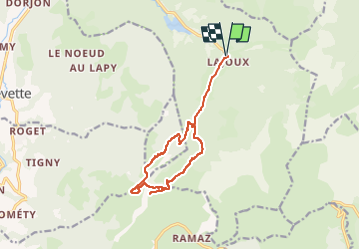

Length
12.9 km

Max alt
1904 m

Uphill gradient
873 m
Km-Effort
25 km

Min alt
1126 m

Downhill gradient
873 m
Boucle
Yes
Creation date :
2022-06-08 20:15:54.977
Updated on :
2022-06-08 20:16:48.03
5h34
Difficulty : Difficult

FREE GPS app for hiking
 SityTrail
IGN / Geographical institutes
SityTrail Plus
The world is yours!
About
Trail Walking of 12.9 km to be discovered at Auvergne-Rhône-Alpes, Upper Savoy, Bellevaux. This trail is proposed by cron.
Positioning
Country:
France
Region :
Auvergne-Rhône-Alpes
Department/Province :
Upper Savoy
Municipality :
Bellevaux
Location:
Unknown
Start:(Dec)
Start:(UTM)
313061 ; 5120114 (32T) N.
Comments