


SityTrail - Parcours visite Chateldon

JackPG
User
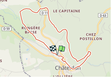

Length
5 km

Max alt
404 m

Uphill gradient
108 m
Km-Effort
6.5 km

Min alt
301 m

Downhill gradient
109 m
Boucle
Yes
Creation date :
2022-06-09 05:37:29.894
Updated on :
2022-06-09 08:38:11.681
1h00
Difficulty : Easy

FREE GPS app for hiking
 SityTrail
IGN / Geographical institutes
SityTrail Plus
The world is yours!
About
Trail Walking of 5 km to be discovered at Auvergne-Rhône-Alpes, Puy-de-Dôme, Châteldon. This trail is proposed by JackPG.
Positioning
Country:
France
Region :
Auvergne-Rhône-Alpes
Department/Province :
Puy-de-Dôme
Municipality :
Châteldon
Location:
Unknown
Start:(Dec)
Start:(UTM)
540122 ; 5091868 (31T) N.
Comments