


Matheysine Sommet de la Cavale

c.gourme
User

Length
9.7 km

Max alt
2128 m

Uphill gradient
1124 m
Km-Effort
25 km

Min alt
998 m

Downhill gradient
1125 m
Boucle
Yes
Creation date :
2022-06-09 06:59:13.0
Updated on :
2022-06-09 11:55:42.384
4h07
Difficulty : Medium

FREE GPS app for hiking
 SityTrail
IGN / Geographical institutes
SityTrail Plus
The world is yours!
About
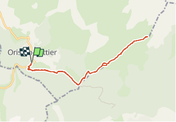
Trail Walking of 9.7 km to be discovered at Auvergne-Rhône-Alpes, Isère, Oris-en-Rattier. This trail is proposed by c.gourme.
Description
Montée raide
Positioning
Country:
France
Region :
Auvergne-Rhône-Alpes
Department/Province :
Isère
Municipality :
Oris-en-Rattier
Location:
Unknown
Start:(Dec)
Start:(UTM)
726647 ; 4977688 (31T) N.
Comments