


r champ de mars depuis 4 vios 12km

07es18
User
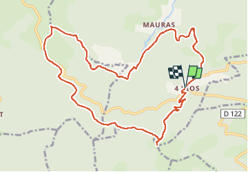

Length
12.2 km

Max alt
1337 m

Uphill gradient
490 m
Km-Effort
18.8 km

Min alt
872 m

Downhill gradient
489 m
Boucle
Yes
Creation date :
2022-06-09 07:20:57.641
Updated on :
2022-06-13 07:16:32.229
3h38
Difficulty : Medium

FREE GPS app for hiking
 SityTrail
IGN / Geographical institutes
SityTrail Plus
The world is yours!
About
Trail Walking of 12.2 km to be discovered at Auvergne-Rhône-Alpes, Ardèche, Marcols-les-Eaux. This trail is proposed by 07es18.
Positioning
Country:
France
Region :
Auvergne-Rhône-Alpes
Department/Province :
Ardèche
Municipality :
Marcols-les-Eaux
Location:
Unknown
Start:(Dec)
Start:(UTM)
610222 ; 4960446 (31T) N.
Comments