Trail Walking Saint-Mars-de-Coutais - Circuit du Bois Charrette - Photo
© OpenStreetMap contributors
Length
Length
10.1 km
Max alt
Max alt
36 m
Uphill gradient
Uphill gradient
69 m
Km-Effort
Km-Effort  
11 km
Min alt
Min alt
3 m
Downhill gradient
Downhill gradient
69 m
Boucle
Boucle
Yes
Creation date :
2022-06-10 13:35:28.259
Updated on :
2022-06-10 13:37:04.406

(0 Reviews)

Walking
Walking
2h30
Difficulty : Medium

Scan this QR Code to open this trail in the SityTrail application

FREE GPS app for hiking

Logo SityTrail SityTrail

IGN / Geographical institutes

Download SityTrail from the App Store Download SityTrail from Google Play

Logo SityTrail SityTrail World

The world is yours!

Download SityTrail from the App Store Download SityTrail from Google Play Download SityTrail on Huawei AppGallery

About

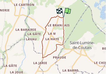
Trail Walking of 10.1 km to be discovered at Pays de la Loire, Loire-Atlantique, Saint-Mars-de-Coutais. This trail is proposed by neoroll44.

Description

Stationnement sur la route menant au Moulin de la Berderie.

(D/A) Depuis La Berderie, revenez au carrefour routier de la Guillotterie.
(1) Au stop, traversez prudemment et allez tout droit.
(2) Prenez à gauche dans le champ, le long du ruisseau et rejoignez un croisement.
(3) Tournez dans le 2e chemin à gauche jusqu’à un nouveau croisement.
(4) Traversez la route, poursuivez tout droit dans le sous-bois et rejoignez une intersection au bout du chemin boisé.
(5) Tournez à gauche sur la route et retrouvez plus loin un carrefour routier.
(6) Au Stop, traversez prudemment et poursuivez tout droit. Traversez, bien plus loin, croisement puis rejoignez le croisement. de la D64
(7) Au Stop, traversez prudemment et poursuivez tout droit dans le chemin jusqu’à un nouveau croisement.
(8) Poursuivez tout droit en empruntant la voie partagée, pédestre et vélo. La suivre jusqu’à rejoindre le carrefour routier de la D61.
(9) Au Stop, traversez prudemment et poursuivez tout droit dans le chemin boisé jusqu’à un croisement.
(10) Poursuivez sur le chemin en face, en suivant le balisage du GRP® Tour du Lac de Grand-Lieu.
(11) À ce croisement ,quittez le GRP®, continuez tout droit et rejoignez le stationnement au (D/A).

Elevation profile

Points of interest

Point of interest Saint-Mars-de-Coutais - Stationnement à la Berderie - Photo
neoroll44
SAINT-MARS-DE-COUTAIS 
Point of interest Saint-Mars-de-Coutais - au stop, tout droit, traversez prudemment - Photo
neoroll44
SAINT-MARS-DE-COUTAIS 
Point of interest Saint-Mars-de-Coutais - Stop. Carrefour routier - Photo
neoroll44
SAINT-MARS-DE-COUTAIS 
Point of interest Saint-Mars-de-Coutais - prendre à gauche dans le champs  - Photo
neoroll44
SAINT-MARS-DE-COUTAIS 
Point of interest Saint-Mars-de-Coutais - Chemin, à gauche - Photo
neoroll44
SAINT-MARS-DE-COUTAIS 
Point of interest Saint-Mars-de-Coutais - Croisement - Photo
neoroll44
SAINT-MARS-DE-COUTAIS 
Point of interest Saint-Mars-de-Coutais - Traversée de route - Photo
neoroll44
SAINT-MARS-DE-COUTAIS 
Point of interest Saint-Mars-de-Coutais - Intersection, à gauche sur la route - Photo
neoroll44
SAINT-MARS-DE-COUTAIS 
Point of interest Saint-Mars-de-Coutais - Jonction route - Photo
neoroll44
SAINT-MARS-DE-COUTAIS 
Point of interest Saint-Mars-de-Coutais - au stop poursuivez tout droit en traversant prudem - Photo
neoroll44
SAINT-MARS-DE-COUTAIS 
Point of interest Saint-Mars-de-Coutais - Stop - Photo
neoroll44
SAINT-MARS-DE-COUTAIS 
Point of interest Machecoul-Saint-Même - au stop, poursuivez tout droit dans le chemin - Photo
neoroll44
MACHECOUL-SAINT-MÊME 
Point of interest Saint-Mars-de-Coutais - Stop de la D64 - Photo
neoroll44
SAINT-MARS-DE-COUTAIS 
Point of interest Saint-Mars-de-Coutais - Croisement, tout droit. Voie partagée - Photo
neoroll44
SAINT-MARS-DE-COUTAIS 
Point of interest Saint-Mars-de-Coutais - au stop, poursuivez tout droit dans le chemin bois - Photo
neoroll44
SAINT-MARS-DE-COUTAIS 
Point of interest Saint-Mars-de-Coutais - D61 - Photo
neoroll44
SAINT-MARS-DE-COUTAIS 
Point of interest Saint-Mars-de-Coutais - Croisement. GRP en face - Photo
neoroll44
SAINT-MARS-DE-COUTAIS 
Point of interest Saint-Mars-de-Coutais - Croisement, en face - Photo
neoroll44
SAINT-MARS-DE-COUTAIS 
Point of interest Saint-Mars-de-Coutais - Stationnement à la Berderie - Photo
neoroll44
SAINT-MARS-DE-COUTAIS 

Positioning

Country:
France
Region :
Pays de la Loire
Department/Province :
Loire-Atlantique
Municipality :
Saint-Mars-de-Coutais
Location:
Unknown
Start:(UTM)
595031 ; 5214511 (30T) N.

Trails nearby

Trail On foot Saint-Mars-de-Coutais - Les Landas - Photo
On foot
PRO

On foot

Easy
Saint-Mars-de-Coutais, Pays de la Loire, Loire-Atlantique, France
8.4 km | 8.9 km-effort
2h 1min
Yes
Trail On foot Saint-Lumine-de-Coutais - La Robrie - Photo
On foot
PRO

On foot

Easy
Saint-Lumine-de-Coutais, Pays de la Loire, Loire-Atlantique, France
9.4 km | 10.2 km-effort
2h 19min
Yes
Trail Walking Sainte-Pazanne - Ste Pazanne_Coulée_Aqueduc - Photo
Walking
neoroll44

Walking

Easy
Sainte-Pazanne, Pays de la Loire, Loire-Atlantique, France
7.9 km | 8.7 km-effort
2h 0min
Yes
Trail Walking Saint-Mars-de-Coutais - Circuit du Tenu - Photo
Walking
neoroll44

Walking

Medium
Saint-Mars-de-Coutais, Pays de la Loire, Loire-Atlantique, France
10.9 km | 11.8 km-effort
3h 10min
Yes
Trail On foot Saint-Philbert-de-Grand-Lieu - Les Hauts du Lac - Photo
On foot
PRO

On foot

Easy
Saint-Philbert-de-Grand-Lieu, Pays de la Loire, Loire-Atlantique, France
7.7 km | 8.3 km-effort
1h 53min
Yes
Trail On foot Saint-Mars-de-Coutais - Le Moulin de la Nation - Photo
On foot
PRO

On foot

Easy
Saint-Mars-de-Coutais, Pays de la Loire, Loire-Atlantique, France
6.5 km | 7.1 km-effort
1h 36min
Yes
Trail Walking Sainte-Pazanne - Ste Pazanne - Photo
Walking
doro44

Walking

Difficult
Sainte-Pazanne, Pays de la Loire, Loire-Atlantique, France
14.2 km | 15.6 km-effort
2h 39min
Yes
Trail On foot Port-Saint-Père - planète sauvage  - Photo
On foot
didier clavier

On foot

Very easy
Port-Saint-Père, Pays de la Loire, Loire-Atlantique, France
9.7 km | 10.4 km-effort
2h 0min
Yes
Trail On foot Port-Saint-Père - planète sauvage  - Photo
On foot
didier clavier

On foot

Very easy
Port-Saint-Père, Pays de la Loire, Loire-Atlantique, France
10.2 km | 10.9 km-effort
Unknown
Yes


Close
My subscriptions