


Le bois de la taillette Feignies

brunobuj
User

Length
50 km

Max alt
196 m

Uphill gradient
420 m
Km-Effort
56 km

Min alt
127 m

Downhill gradient
402 m
Boucle
No
Creation date :
2022-06-11 07:33:59.081
Updated on :
2022-06-11 15:49:31.671
8h14
Difficulty : Very difficult

FREE GPS app for hiking
 SityTrail
IGN / Geographical institutes
SityTrail Plus
The world is yours!
About
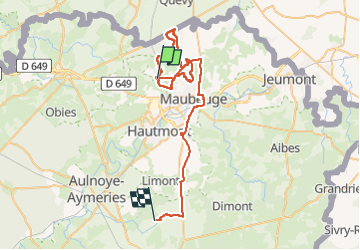
Trail Walking of 50 km to be discovered at Hauts-de-France, Nord, Feignies. This trail is proposed by brunobuj.
Positioning
Country:
France
Region :
Hauts-de-France
Department/Province :
Nord
Municipality :
Feignies
Location:
Unknown
Start:(Dec)
Start:(UTM)
565356 ; 5572039 (31U) N.
Comments