


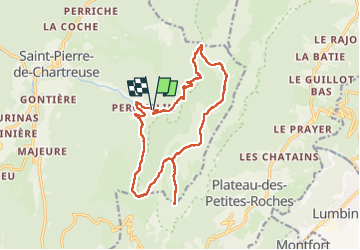
Dent de crolles

Tof Tof
User

Length
17.1 km

Max alt
2038 m

Uphill gradient
1209 m
Km-Effort
33 km

Min alt
967 m

Downhill gradient
1222 m
Boucle
Yes
Creation date :
2022-06-11 08:56:32.809
Updated on :
2022-06-11 17:16:37.779
6h00
Difficulty : Difficult

FREE GPS app for hiking
 SityTrail
IGN / Geographical institutes
SityTrail Plus
The world is yours!
About
Trail Walking of 17.1 km to be discovered at Auvergne-Rhône-Alpes, Isère, Saint-Pierre-de-Chartreuse. This trail is proposed by Tof Tof.
Positioning
Country:
France
Region :
Auvergne-Rhône-Alpes
Department/Province :
Isère
Municipality :
Saint-Pierre-de-Chartreuse
Location:
Unknown
Start:(Dec)
Start:(UTM)
723168 ; 5023670 (31T) N.
Comments