


Nalinnes etang du chêneau

pilmolt
User
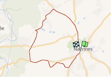

Length
7.5 km

Max alt
224 m

Uphill gradient
69 m
Km-Effort
8.5 km

Min alt
190 m

Downhill gradient
74 m
Boucle
Yes
Creation date :
2022-06-12 07:10:52.0
Updated on :
2022-06-12 08:48:46.272
1h35
Difficulty : Medium

FREE GPS app for hiking
 SityTrail
IGN / Geographical institutes
SityTrail Plus
The world is yours!
About
Trail Walking of 7.5 km to be discovered at Wallonia, Hainaut, Ham-sur-Heure-Nalinnes. This trail is proposed by pilmolt.
Description
Pierre Serge Jacky Bernard
Positioning
Country:
Belgium
Region :
Wallonia
Department/Province :
Hainaut
Municipality :
Ham-sur-Heure-Nalinnes
Location:
Unknown
Start:(Dec)
Start:(UTM)
602894 ; 5575677 (31U) N.
Comments