


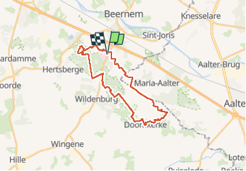
Beernem - Bulskampsveld - Doomkerke - Beernem

kimpej
User

Length
25 km

Max alt
39 m

Uphill gradient
260 m
Km-Effort
28 km

Min alt
12 m

Downhill gradient
260 m
Boucle
Yes
Creation date :
2022-06-12 07:00:01.167
Updated on :
2022-06-12 12:18:22.031
5h13
Difficulty : Easy

FREE GPS app for hiking
 SityTrail
IGN / Geographical institutes
SityTrail Plus
The world is yours!
About
Trail Walking of 25 km to be discovered at Flanders, West Flanders, Beernem. This trail is proposed by kimpej.
Positioning
Country:
Belgium
Region :
Flanders
Department/Province :
West Flanders
Municipality :
Beernem
Location:
Beernem
Start:(Dec)
Start:(UTM)
522338 ; 5662677 (31U) N.
Comments