Trail Walking Saint-Christophe-en-Oisans - Rando depart du refuge du Carrelet et arrivée à La Berarde - Photo

Rando depart du refuge du Carrelet et arrivée à La Berarde

 HF89
HF89

User

© OpenStreetMap contributors
Length
Length
4.4 km
Max alt
Max alt
1906 m
Uphill gradient
Uphill gradient
21 m
Km-Effort
Km-Effort  
5.3 km
Min alt
Min alt
1708 m
Downhill gradient
Downhill gradient
212 m
Boucle
Boucle
No
Creation date :
2022-06-13 12:52:22.611
Updated on :
2023-03-04 13:32:41.362

(0 Reviews)

Walking
Walking
1h10
Difficulty : Easy

Scan this QR Code to open this trail in the SityTrail application

FREE GPS app for hiking

Logo SityTrail SityTrail

IGN / Geographical institutes

Download SityTrail from the App Store Download SityTrail from Google Play

Logo SityTrail SityTrail World

The world is yours!

Download SityTrail from the App Store Download SityTrail from Google Play Download SityTrail on Huawei AppGallery

About

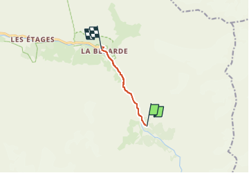
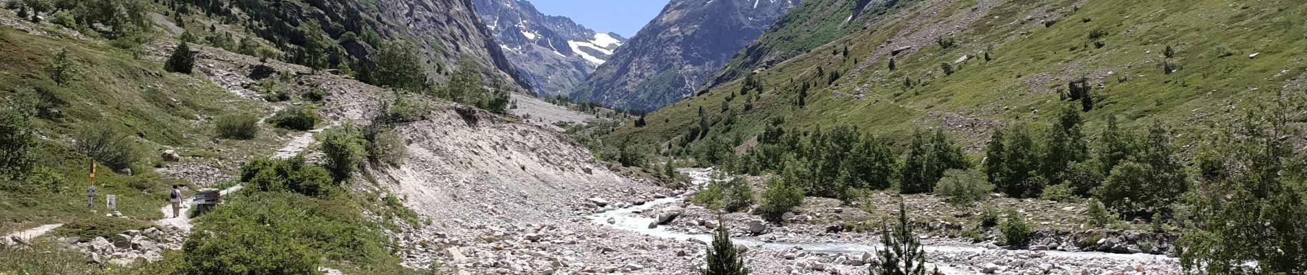
Trail Walking of 4.4 km to be discovered at Auvergne-Rhône-Alpes, Isère, Saint-Christophe-en-Oisans. This trail is proposed by HF89.

Description

Départ du refuge du Carrelet .
8,8 km A/R.

Elevation profile

Photos

Positioning

Country:
France
Region :
Auvergne-Rhône-Alpes
Department/Province :
Isère
Municipality :
Saint-Christophe-en-Oisans
Location:
Unknown
Start:(UTM)
287919 ; 4976051 (32T) N.

Trails nearby

Trail Walking Saint-Christophe-en-Oisans - Malraux Refuge du Chateleret - Photo
Walking
rapako

Walking

Easy
Saint-Christophe-en-Oisans, Auvergne-Rhône-Alpes, Isère, France
12.1 km | 19.4 km-effort
5h 26min
Yes
Trail Walking Saint-Christophe-en-Oisans - Oisans - Vallon des Etages - 6.5km 375m 2h20 - 2018 06 19 - public - Photo
Walking
Orcal37

Walking

Medium
Saint-Christophe-en-Oisans, Auvergne-Rhône-Alpes, Isère, France
6.3 km | 11.2 km-effort
3h 20min
Yes
Trail Walking Saint-Christophe-en-Oisans - Oisans - La Bérarde Chatelleret - 11km 400m 3h25 - 2018 06 22 - public - Photo
Walking
Orcal37

Walking

Medium
Saint-Christophe-en-Oisans, Auvergne-Rhône-Alpes, Isère, France
10.8 km | 16 km-effort
5h 30min
Yes
Trail Walking Saint-Christophe-en-Oisans - REFUGE DE CHATELLERET depuis LA BERARDE-07-09-2016 - Photo
Walking
RD78-38

Walking

Easy
Saint-Christophe-en-Oisans, Auvergne-Rhône-Alpes, Isère, France
14.9 km | 25 km-effort
6h 30min
Yes
Trail Walking Saint-Christophe-en-Oisans - MONTÉE vers LE REFUGE DU SOREILLER-08-09-2016 - Photo
Walking
RD78-38

Walking

Medium
Saint-Christophe-en-Oisans, Auvergne-Rhône-Alpes, Isère, France
5.6 km | 16.9 km-effort
4h 5min
No
Trail Walking Saint-Christophe-en-Oisans - Oisans - Vénéon - Les Etages - Photo
Walking
Orcal37

Walking

Easy
Saint-Christophe-en-Oisans, Auvergne-Rhône-Alpes, Isère, France
5.2 km | 7.6 km-effort
3h 15min
Yes
Trail Walking Saint-Christophe-en-Oisans - Oisans - Vénéon - La Bérarde - Le Chatelleret - Photo
Walking
Orcal37

Walking

Medium
Saint-Christophe-en-Oisans, Auvergne-Rhône-Alpes, Isère, France
7.9 km | 10.8 km-effort
2h 50min
Yes
Trail Walking Saint-Christophe-en-Oisans - Oisans La Bérarde Vallée du Vénéon  - Photo
Walking
Orcal37

Walking

Medium
Saint-Christophe-en-Oisans, Auvergne-Rhône-Alpes, Isère, France
13.4 km | 18.5 km-effort
4h 1min
Yes
Trail Walking Saint-Christophe-en-Oisans - Crique Glaciaire de Bonne Piere - Photo
Walking
franck38

Walking

Difficult
Saint-Christophe-en-Oisans, Auvergne-Rhône-Alpes, Isère, France
11.4 km | 27 km-effort
5h 27min
Yes


Close
My subscriptions