


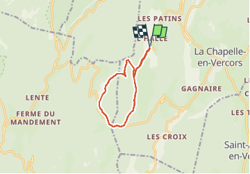
Col de carri -Maupas

brigitBB26
User

Length
10.3 km

Max alt
1219 m

Uphill gradient
284 m
Km-Effort
14.1 km

Min alt
1013 m

Downhill gradient
284 m
Boucle
Yes
Creation date :
2022-06-13 07:34:50.522
Updated on :
2022-06-13 19:57:30.456
3h52
Difficulty : Difficult

FREE GPS app for hiking
 SityTrail
IGN / Geographical institutes
SityTrail Plus
The world is yours!
About
Trail Walking of 10.3 km to be discovered at Auvergne-Rhône-Alpes, Drôme, La Chapelle-en-Vercors. This trail is proposed by brigitBB26.
Positioning
Country:
France
Region :
Auvergne-Rhône-Alpes
Department/Province :
Drôme
Municipality :
La Chapelle-en-Vercors
Location:
Unknown
Start:(Dec)
Start:(UTM)
687807 ; 4982559 (31T) N.
Comments