


Mourre Negre

ARPF
User
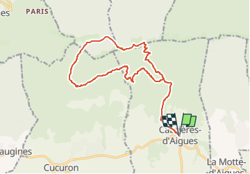

Length
18.9 km

Max alt
1122 m

Uphill gradient
1004 m
Km-Effort
32 km

Min alt
403 m

Downhill gradient
997 m
Boucle
Yes
Creation date :
2022-06-14 07:28:17.048
Updated on :
2023-03-13 17:23:07.135
7h37
Difficulty : Very difficult

FREE GPS app for hiking
 SityTrail
IGN / Geographical institutes
SityTrail Plus
The world is yours!
About
Trail On foot of 18.9 km to be discovered at Provence-Alpes-Côte d'Azur, Vaucluse, Cabrières-d'Aigues. This trail is proposed by ARPF.
Positioning
Country:
France
Region :
Provence-Alpes-Côte d'Azur
Department/Province :
Vaucluse
Municipality :
Cabrières-d'Aigues
Location:
Unknown
Start:(Dec)
Start:(UTM)
700993 ; 4850961 (31T) N.
Comments