Trail Walking Stavelot - Promenade du point de vue de Ster  - Photo

Promenade du point de vue de Ster

« L’heure de la fin des découvertes ne sonne jamais. » Colette GUIDE+

© OpenStreetMap contributors
Length
Length
5.2 km
Max alt
Max alt
498 m
Uphill gradient
Uphill gradient
151 m
Km-Effort
Km-Effort  
7.2 km
Min alt
Min alt
348 m
Downhill gradient
Downhill gradient
156 m
Boucle
Boucle
Yes
Creation date :
2022-06-14 18:25:08.754
Updated on :
2022-06-15 18:35:08.249

(0 Reviews)

Walking
Walking
1h38
Difficulty : Medium

Scan this QR Code to open this trail in the SityTrail application

FREE GPS app for hiking

Logo SityTrail SityTrail

IGN / Geographical institutes

Download SityTrail from the App Store Download SityTrail from Google Play

Logo SityTrail SityTrail World

The world is yours!

Download SityTrail from the App Store Download SityTrail from Google Play Download SityTrail on Huawei AppGallery

About

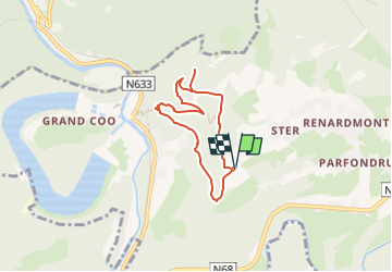
Trail Walking of 5.2 km to be discovered at Wallonia, Liège, Stavelot. This trail is proposed by Au fil de nos découvertes.

Description

Profitez des magnifiques vues sur le Lac! 😍
🅿️ Départ et Parking:
Chemin des mazures
4970 Stavelot
🥾 Prévoir de bonnes chaussures de marche.
Cela peut être boueux à certains endroits.
▶️ Suivre la balise "rectangle rouge"
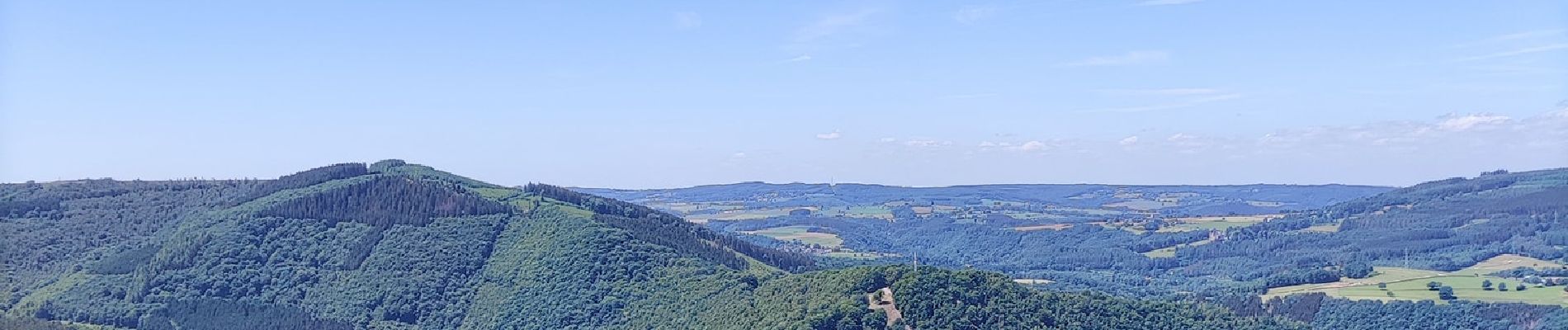
Cette promenade vous emmène à travers la forêt vers le point de vue de Ster. ❤️
Nous avons fait un petit détour après le 1er point de vue, vers un deuxième, qui se trouve quelques centaines de mètres plus loin. 👌
(Au lieu de descendre, continuez tout droit).
Lors des beaux jours, vous y verrez certainement des parapentistes et la vue sur les lacs de Coo y est incroyable. 😱
Vous passerez par le Belvédère Thiry et le Belvédère Hardy.
Après, toutes ses jolies vues, une grimpette s'impose pour revenir au point de départ. 😁
Chiens autorisés en laisse. 🐩🐶🐕
Convient pour les enfants . 👱👱‍♂️  
Ne convient pas pour les poussettes et personnes à mobilité réduite. 👨‍🦽👩‍🦽👶
N'hésitez pas à aller faire un tour sur notre site internet et nos réseaux :
www.aufildenosdecouvertes.com
www.facebook.com/aufildenosdecouvertes
https://www.instagram.com/au_fil_de_nos_decouvertes

Elevation profile

Photos

Positioning

Country:
Belgium
Region :
Wallonia
Department/Province :
Liège
Municipality :
Stavelot
Location:
Unknown
Start:(UTM)
705732 ; 5585838 (31U) N.

Trails nearby

Trail Walking Trois-Ponts - RB-Lg-29_Wanne - Photo
Walking
PRO

Walking

(5)
Trois-Ponts, Wallonia, Liège, Belgium
22 km | 29 km-effort
6h 41min
Yes
Trail Walking Trois-Ponts - RB-Lg-27_Trois-Ponts - Photo
Walking
PRO

Walking

(7)
Trois-Ponts, Wallonia, Liège, Belgium
23 km | 33 km-effort
7h 30min
Yes
Trail Walking Stavelot - 2021-06-30_12h14m27_stavelot_13km_new - Photo
Walking
GUIDE
mumu.larandonneuse

Walking

Medium
(2)
Stavelot, Wallonia, Liège, Belgium
13.4 km | 19.8 km-effort
4h 30min
Yes
Trail Walking Stoumont - IR-224 & RB-SoirMag-06_La-Glaise-_QR3_Rac1Rac2_13_9_km - Photo
Walking
PRO

Walking

Medium
(2)
Stoumont, Wallonia, Liège, Belgium
13.9 km | 19.8 km-effort
4h 30min
Yes
Trail Walking Stoumont - 2021-03-12_16h39m43_LaGleizeP3TourduMontSaintVictor - Photo
Walking
GUIDE
mumu.larandonneuse

Walking

Medium
(2)
Stoumont, Wallonia, Liège, Belgium
15.8 km | 22 km-effort
5h 2min
Yes
Trail Walking Stavelot - 2021-03-10_14h59m08_1227 - Photo
Walking
GUIDE
mumu.larandonneuse

Walking

Difficult
(3)
Stavelot, Wallonia, Liège, Belgium
18.8 km | 26 km-effort
5h 53min
No
Trail Walking Trois-Ponts - RB-Lg-27_Trois-Ponts_via-racc - Photo
Walking
PRO

Walking

Very difficult
(1)
Trois-Ponts, Wallonia, Liège, Belgium
16.9 km | 25 km-effort
5h 36min
Yes
Trail Walking Stavelot - Chemin des Sources |stage 3 STAVELOT - HOCKAI - Photo
Walking
PRO

Walking

Very difficult
(1)
Stavelot, Wallonia, Liège, Belgium
19 km | 25 km-effort
5h 45min
No
Trail Trail Stavelot - Extratrail - Stavelot (red) 23km - Photo
Trail
PRO

Trail

Very difficult
(1)
Stavelot, Wallonia, Liège, Belgium
23 km | 35 km-effort
Unknown
Yes


Close
My subscriptions