


Belledonne Premile Col de la Madeleine

c.gourme
User
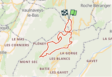

Length
15.8 km

Max alt
1540 m

Uphill gradient
784 m
Km-Effort
26 km

Min alt
1074 m

Downhill gradient
783 m
Boucle
Yes
Creation date :
2022-06-14 07:55:12.0
Updated on :
2022-06-15 09:46:11.997
5h47
Difficulty : Easy

FREE GPS app for hiking
 SityTrail
IGN / Geographical institutes
SityTrail Plus
The world is yours!
About
Trail Walking of 15.8 km to be discovered at Auvergne-Rhône-Alpes, Isère, Vaulnaveys-le-Haut. This trail is proposed by c.gourme.
Positioning
Country:
France
Region :
Auvergne-Rhône-Alpes
Department/Province :
Isère
Municipality :
Vaulnaveys-le-Haut
Location:
Unknown
Start:(Dec)
Start:(UTM)
723986 ; 4998175 (31T) N.
Comments