


Ouest de LAMBESC

didierc13
User
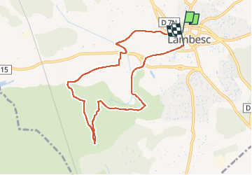

Length
8.6 km

Max alt
200 m

Uphill gradient
103 m
Km-Effort
10 km

Min alt
153 m

Downhill gradient
105 m
Boucle
No
Creation date :
2022-06-16 04:09:20.0
Updated on :
2022-06-16 05:47:36.305
1h37
Difficulty : Very easy

FREE GPS app for hiking
 SityTrail
IGN / Geographical institutes
SityTrail Plus
The world is yours!
About
Trail Walking of 8.6 km to be discovered at Provence-Alpes-Côte d'Azur, Bouches-du-Rhône, Lambesc. This trail is proposed by didierc13.
Positioning
Country:
France
Region :
Provence-Alpes-Côte d'Azur
Department/Province :
Bouches-du-Rhône
Municipality :
Lambesc
Location:
Unknown
Start:(Dec)
Start:(UTM)
682277 ; 4836051 (31T) N.
Comments