


trevans 16 juin 2022

rlebasque
User
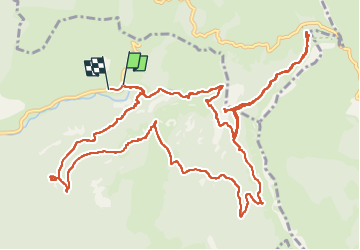

Length
17.2 km

Max alt
992 m

Uphill gradient
744 m
Km-Effort
27 km

Min alt
600 m

Downhill gradient
750 m
Boucle
Yes
Creation date :
2022-06-16 06:10:59.312
Updated on :
2022-06-16 13:32:39.023
7h16
Difficulty : Very difficult

FREE GPS app for hiking
 SityTrail
IGN / Geographical institutes
SityTrail Plus
The world is yours!
About
Trail Walking of 17.2 km to be discovered at Provence-Alpes-Côte d'Azur, Alpes-de-Haute-Provence, Estoublon. This trail is proposed by rlebasque.
Positioning
Country:
France
Region :
Provence-Alpes-Côte d'Azur
Department/Province :
Alpes-de-Haute-Provence
Municipality :
Estoublon
Location:
Unknown
Start:(Dec)
Start:(UTM)
277081 ; 4869903 (32T) N.
Comments