


Chaud Clapier - Font d'Urle

guy77340
User
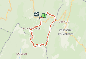

Length
13.9 km

Max alt
1638 m

Uphill gradient
503 m
Km-Effort
21 km

Min alt
1336 m

Downhill gradient
517 m
Boucle
Yes
Creation date :
2022-06-16 08:21:35.812
Updated on :
2022-06-16 14:21:10.553
3h56
Difficulty : Difficult

FREE GPS app for hiking
 SityTrail
IGN / Geographical institutes
SityTrail Plus
The world is yours!
About
Trail Walking of 13.9 km to be discovered at Auvergne-Rhône-Alpes, Drôme, Bouvante. This trail is proposed by guy77340.
Positioning
Country:
France
Region :
Auvergne-Rhône-Alpes
Department/Province :
Drôme
Municipality :
Bouvante
Location:
Unknown
Start:(Dec)
Start:(UTM)
684323 ; 4975244 (31T) N.
Comments