


beaune - ste marguerite - arcenant

XavierFaidix
User
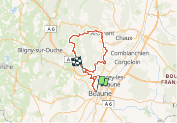

Length
45 km

Max alt
589 m

Uphill gradient
1197 m
Km-Effort
61 km

Min alt
217 m

Downhill gradient
1106 m
Boucle
No
Creation date :
2022-06-13 11:59:31.275
Updated on :
2022-06-17 06:03:12.637
4h00
Difficulty : Medium

FREE GPS app for hiking
 SityTrail
IGN / Geographical institutes
SityTrail Plus
The world is yours!
About
Trail Mountain bike of 45 km to be discovered at Bourgogne-Franche-Comté, Côte-d'Or, Beaune. This trail is proposed by XavierFaidix.
Description
plutôt VAE
Positioning
Country:
France
Region :
Bourgogne-Franche-Comté
Department/Province :
Côte-d'Or
Municipality :
Beaune
Location:
Unknown
Start:(Dec)
Start:(UTM)
638899 ; 5209670 (31T) N.
Comments