


Chaud Clapier - Vassieux en Vercors

guy77340
User
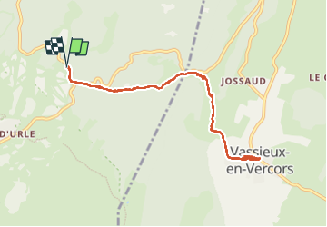

Length
10.3 km

Max alt
1441 m

Uphill gradient
426 m
Km-Effort
15.9 km

Min alt
1052 m

Downhill gradient
421 m
Boucle
Yes
Creation date :
2022-06-17 06:47:53.092
Updated on :
2022-06-17 14:11:58.018
3h21
Difficulty : Difficult

FREE GPS app for hiking
 SityTrail
IGN / Geographical institutes
SityTrail Plus
The world is yours!
About
Trail Walking of 10.3 km to be discovered at Auvergne-Rhône-Alpes, Drôme, Bouvante. This trail is proposed by guy77340.
Positioning
Country:
France
Region :
Auvergne-Rhône-Alpes
Department/Province :
Drôme
Municipality :
Bouvante
Location:
Unknown
Start:(Dec)
Start:(UTM)
684265 ; 4975357 (31T) N.
Comments