


Francillon roubion boucle

elcanario
User
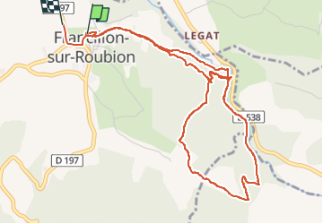

Length
6 km

Max alt
431 m

Uphill gradient
155 m
Km-Effort
8.1 km

Min alt
341 m

Downhill gradient
167 m
Boucle
Yes
Creation date :
2022-06-17 09:32:18.682
Updated on :
2022-06-17 14:28:11.249
4h55
Difficulty : Easy

FREE GPS app for hiking
 SityTrail
IGN / Geographical institutes
SityTrail Plus
The world is yours!
About
Trail Walking of 6 km to be discovered at Auvergne-Rhône-Alpes, Drôme, Francillon-sur-Roubion. This trail is proposed by elcanario.
Description
randonnée avec baignade
Positioning
Country:
France
Region :
Auvergne-Rhône-Alpes
Department/Province :
Drôme
Municipality :
Francillon-sur-Roubion
Location:
Unknown
Start:(Dec)
Start:(UTM)
665447 ; 4943380 (31T) N.
Comments