


Dun sur Meuse - Varennes en argonnes

iznogud
User
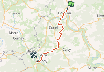

Length
32 km

Max alt
337 m

Uphill gradient
570 m
Km-Effort
40 km

Min alt
153 m

Downhill gradient
583 m
Boucle
No
Creation date :
2022-06-19 06:01:32.0
Updated on :
2022-06-19 16:52:03.308
10h46
Difficulty : Very difficult

FREE GPS app for hiking
 SityTrail
IGN / Geographical institutes
SityTrail Plus
The world is yours!
About
Trail Walking of 32 km to be discovered at Grand Est, Meuse, Dun-sur-Meuse. This trail is proposed by iznogud.
Positioning
Country:
France
Region :
Grand Est
Department/Province :
Meuse
Municipality :
Dun-sur-Meuse
Location:
Unknown
Start:(Dec)
Start:(UTM)
658333 ; 5473067 (31U) N.
Comments