


Jonzieux Marlhes Le Sapt

psesjs
User
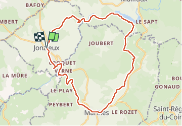

Length
19.9 km

Max alt
1019 m

Uphill gradient
504 m
Km-Effort
27 km

Min alt
813 m

Downhill gradient
501 m
Boucle
Yes
Creation date :
2022-06-15 07:05:12.984
Updated on :
2022-06-19 18:34:26.08
4h42
Difficulty : Very easy

FREE GPS app for hiking
 SityTrail
IGN / Geographical institutes
SityTrail Plus
The world is yours!
About
Trail Walking of 19.9 km to be discovered at Auvergne-Rhône-Alpes, Loire, Jonzieux. This trail is proposed by psesjs.
Positioning
Country:
France
Region :
Auvergne-Rhône-Alpes
Department/Province :
Loire
Municipality :
Jonzieux
Location:
Unknown
Start:(Dec)
Start:(UTM)
606669 ; 5018794 (31T) N.
Comments