


Les grès d'Annot-20-05-22

Christiancordin
User

Length
6.8 km

Max alt
1031 m

Uphill gradient
417 m
Km-Effort
12.4 km

Min alt
692 m

Downhill gradient
430 m
Boucle
No
Creation date :
2022-06-20 08:48:40.665
Updated on :
2022-06-25 16:27:03.291
2h20
Difficulty : Medium

FREE GPS app for hiking
 SityTrail
IGN / Geographical institutes
SityTrail Plus
The world is yours!
About
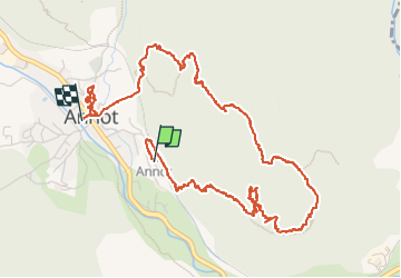
Trail Walking of 6.8 km to be discovered at Provence-Alpes-Côte d'Azur, Alpes-de-Haute-Provence, Annot. This trail is proposed by Christiancordin.
Description
Départ PK de la gare-les Grès-chambre du Roi-les Portettes-les Espaluns-la chapelle-visite d'Annot.
Photos


Positioning
Country:
France
Region :
Provence-Alpes-Côte d'Azur
Department/Province :
Alpes-de-Haute-Provence
Municipality :
Annot
Location:
Unknown
Start:(Dec)
Start:(UTM)
313265 ; 4870470 (32T) N.
Comments