


Lac Aubert et Lac Aumar

GOHIER
User
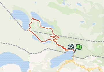

Length
9.4 km

Max alt
2207 m

Uphill gradient
382 m
Km-Effort
14.5 km

Min alt
1865 m

Downhill gradient
380 m
Boucle
Yes
Creation date :
2022-06-20 08:28:02.0
Updated on :
2022-06-20 15:35:26.65
5h10
Difficulty : Easy

FREE GPS app for hiking
 SityTrail
IGN / Geographical institutes
SityTrail Plus
The world is yours!
About
Trail Walking of 9.4 km to be discovered at Occitania, Hautespyrenees, Saint-Lary-Soulan. This trail is proposed by GOHIER.
Description
Tres beau parcours varié, nombreux lacs.
Positioning
Country:
France
Region :
Occitania
Department/Province :
Hautespyrenees
Municipality :
Saint-Lary-Soulan
Location:
Unknown
Start:(Dec)
Start:(UTM)
268684 ; 4745583 (31T) N.
Comments