


Depuis Mandeure

tiene
User
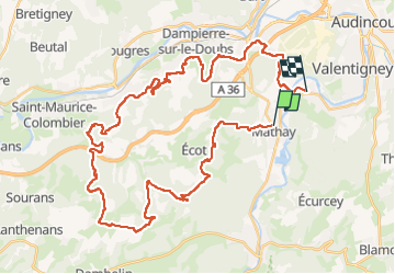

Length
46 km

Max alt
537 m

Uphill gradient
1169 m
Km-Effort
62 km

Min alt
313 m

Downhill gradient
1175 m
Boucle
No
Creation date :
2022-06-20 11:42:47.399
Updated on :
2022-06-21 13:45:09.662
3h17
Difficulty : Very difficult

FREE GPS app for hiking
 SityTrail
IGN / Geographical institutes
SityTrail Plus
The world is yours!
About
Trail Mountain bike of 46 km to be discovered at Bourgogne-Franche-Comté, Doubs, Mathay. This trail is proposed by tiene.
Description
Superbe sortie par temps sec et chaud.
Positioning
Country:
France
Region :
Bourgogne-Franche-Comté
Department/Province :
Doubs
Municipality :
Mathay
Location:
Unknown
Start:(Dec)
Start:(UTM)
332703 ; 5256160 (32T) N.
Comments