Trail Walking Ciron - CIRON - Photo
 CAMBON
CAMBON

User

© OpenStreetMap contributors
Length
Length
9.9 km
Max alt
Max alt
116 m
Uphill gradient
Uphill gradient
66 m
Km-Effort
Km-Effort  
10.8 km
Min alt
Min alt
92 m
Downhill gradient
Downhill gradient
64 m
Boucle
Boucle
Yes
Creation date :
2014-12-10 00:00:00.0
Updated on :
2014-12-10 00:00:00.0

(0 Reviews)

Walking
Walking
2h24
Difficulty : Easy

Scan this QR Code to open this trail in the SityTrail application

FREE GPS app for hiking

Logo SityTrail SityTrail

IGN / Geographical institutes

Download SityTrail from the App Store Download SityTrail from Google Play

Logo SityTrail SityTrail World

The world is yours!

Download SityTrail from the App Store Download SityTrail from Google Play Download SityTrail on Huawei AppGallery

About

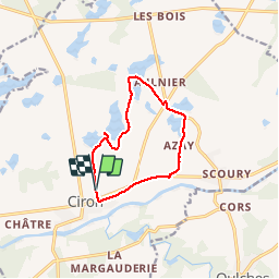
Trail Walking of 9.9 km to be discovered at Centre-Loire Valley, Indre, Ciron. This trail is proposed by CAMBON.

Description

Randonnée aux bord des étang, observation des oiseaux.
Le travail de l'homme sur le modelage de son environement

Elevation profile

Photos

Points of interest

Point of interest Ciron - Point 1 - Photo
CAMBON
CIRON 
Point of interest Ciron - Point 2 - Photo
CAMBON
CIRON 
Point of interest Ciron - TOURNER A DROITE - Photo
CAMBON
Point of interest Ciron - Point 4 - Photo
CAMBON
CIRON 
Point of interest Ciron - VOIE VERTE - Photo
CAMBON
CIRON 

Positioning

Country:
France
Region :
Centre-Loire Valley
Department/Province :
Indre
Municipality :
Ciron
Location:
Unknown
Start:(UTM)
366020 ; 5165836 (31T) N.

Trails nearby

Trail Walking Ciron - Ciron - Photo
Walking
mclafarie

Walking

Very easy
Ciron, Centre-Loire Valley, Indre, France
6.5 km | 7 km-effort
1h 34min
Yes


Close
My subscriptions