


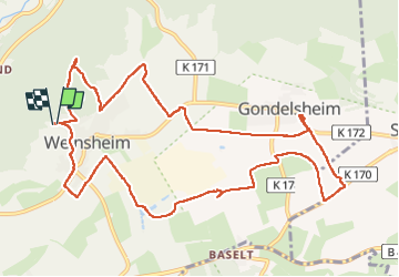
Weinsheim dag 3

Geert H.
User

Length
12.6 km

Max alt
631 m

Uphill gradient
200 m
Km-Effort
15.3 km

Min alt
497 m

Downhill gradient
201 m
Boucle
Yes
Creation date :
2022-06-21 11:46:28.06
Updated on :
2022-06-21 14:52:20.25
2h44
Difficulty : Easy

FREE GPS app for hiking
 SityTrail
IGN / Geographical institutes
SityTrail Plus
The world is yours!
About
Trail Walking of 12.6 km to be discovered at Rhineland-Palatinate, Eifelkreis Bitburg-Prüm, Weinsheim. This trail is proposed by Geert H..
Description
Grotendeels verharde paden en wegen. Heel af en toe door het bos.
Photos


Positioning
Country:
Germany
Region :
Rhineland-Palatinate
Department/Province :
Eifelkreis Bitburg-Prüm
Municipality :
Weinsheim
Location:
Unknown
Start:(Dec)
Start:(UTM)
319356 ; 5567558 (32U) N.
Comments