


Pointe de Tal Ar Gid

psesjs
User
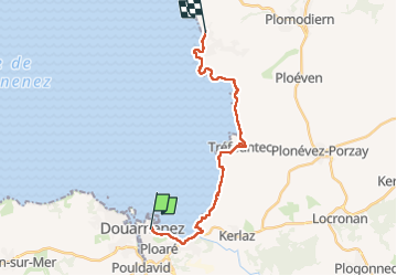

Length
18.9 km

Max alt
64 m

Uphill gradient
347 m
Km-Effort
24 km

Min alt
0 m

Downhill gradient
361 m
Boucle
No
Creation date :
2022-06-22 07:23:46.702
Updated on :
2022-06-22 14:02:11.71
5h05
Difficulty : Easy

FREE GPS app for hiking
 SityTrail
IGN / Geographical institutes
SityTrail Plus
The world is yours!
About
Trail Walking of 18.9 km to be discovered at Brittany, Finistère, Douarnenez. This trail is proposed by psesjs.
Positioning
Country:
France
Region :
Brittany
Department/Province :
Finistère
Municipality :
Douarnenez
Location:
Unknown
Start:(Dec)
Start:(UTM)
401288 ; 5327654 (30U) N.
Comments