


2022-06-22_18h28m36_Puget Thenier col de Velac

Renefrt
User
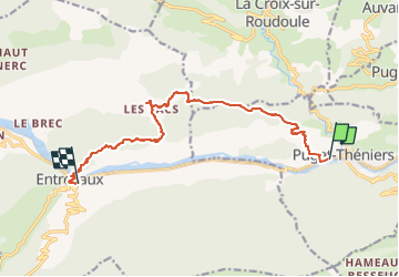

Length
12.6 km

Max alt
1020 m

Uphill gradient
808 m
Km-Effort
23 km

Min alt
405 m

Downhill gradient
744 m
Boucle
No
Creation date :
2022-06-22 16:28:37.329
Updated on :
2022-06-23 09:15:19.248
5h15
Difficulty : Difficult

FREE GPS app for hiking
 SityTrail
IGN / Geographical institutes
SityTrail Plus
The world is yours!
About
Trail Walking of 12.6 km to be discovered at Provence-Alpes-Côte d'Azur, Maritime Alps, Puget-Théniers. This trail is proposed by Renefrt.
Positioning
Country:
France
Region :
Provence-Alpes-Côte d'Azur
Department/Province :
Maritime Alps
Municipality :
Puget-Théniers
Location:
Unknown
Start:(Dec)
Start:(UTM)
330761 ; 4868989 (32T) N.
Comments