


La Grange aux Bois du 22/06/2022

VANDERPUTTENMi
User GUIDE
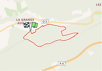

Length
6.6 km

Max alt
253 m

Uphill gradient
118 m
Km-Effort
8.2 km

Min alt
164 m

Downhill gradient
120 m
Boucle
Yes
Creation date :
2022-06-22 09:26:15.94
Updated on :
2022-06-23 05:58:02.287
1h55
Difficulty : Medium

FREE GPS app for hiking
 SityTrail
IGN / Geographical institutes
SityTrail Plus
The world is yours!
About
Trail Walking of 6.6 km to be discovered at Grand Est, Marne, Sainte-Menehould. This trail is proposed by VANDERPUTTENMi.
Photos


Positioning
Country:
France
Region :
Grand Est
Department/Province :
Marne
Municipality :
Sainte-Menehould
Location:
Unknown
Start:(Dec)
Start:(UTM)
641881 ; 5440062 (31U) N.
Comments