


Mirabelle

Yannick.Boireau
User
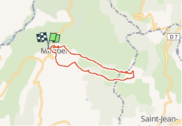

Length
6.5 km

Max alt
581 m

Uphill gradient
206 m
Km-Effort
9.2 km

Min alt
437 m

Downhill gradient
200 m
Boucle
Yes
Creation date :
2022-06-23 07:30:20.319
Updated on :
2022-06-23 10:07:06.207
2h03
Difficulty : Medium

FREE GPS app for hiking
 SityTrail
IGN / Geographical institutes
SityTrail Plus
The world is yours!
About
Trail Walking of 6.5 km to be discovered at Auvergne-Rhône-Alpes, Ardèche, Mirabel. This trail is proposed by Yannick.Boireau.
Positioning
Country:
France
Region :
Auvergne-Rhône-Alpes
Department/Province :
Ardèche
Municipality :
Mirabel
Location:
Unknown
Start:(Dec)
Start:(UTM)
618724 ; 4940611 (31T) N.
Comments