


Givry -chatel moron - st Martin de vaux - St Denis de vaux

XavierFaidix
User
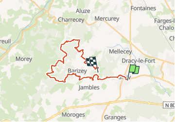

Length
28 km

Max alt
498 m

Uphill gradient
943 m
Km-Effort
40 km

Min alt
209 m

Downhill gradient
727 m
Boucle
No
Creation date :
2022-06-23 07:08:50.081
Updated on :
2022-06-23 12:45:48.602
3h35
Difficulty : Medium

FREE GPS app for hiking
 SityTrail
IGN / Geographical institutes
SityTrail Plus
The world is yours!
About
Trail Mountain bike of 28 km to be discovered at Bourgogne-Franche-Comté, Saône-et-Loire, Givry. This trail is proposed by XavierFaidix.
Positioning
Country:
France
Region :
Bourgogne-Franche-Comté
Department/Province :
Saône-et-Loire
Municipality :
Givry
Location:
Unknown
Start:(Dec)
Start:(UTM)
633473 ; 5182166 (31T) N.
Comments