


Plan de la tour-Col de Vignon.

Sugg
User
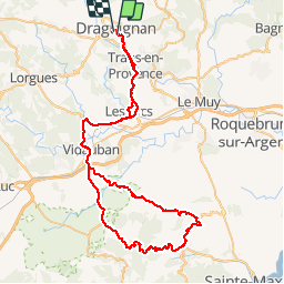

Length
87 km

Max alt
366 m

Uphill gradient
1211 m
Km-Effort
103 km

Min alt
39 m

Downhill gradient
1217 m
Boucle
No
Creation date :
2019-03-22 17:00:06.764
Updated on :
2019-03-22 17:00:06.853
4h40
Difficulty : Medium

FREE GPS app for hiking
 SityTrail
IGN / Geographical institutes
SityTrail Plus
The world is yours!
About
Trail Cycle of 87 km to be discovered at Provence-Alpes-Côte d'Azur, Var, Draguignan. This trail is proposed by Sugg.
Description
Sortie Vélo Cyclo de Restons en forme le 24 juillet 2014.( la durée, c'est avec les pauses, l'appli ne décompte pas les arrêts ).
Positioning
Country:
France
Region :
Provence-Alpes-Côte d'Azur
Department/Province :
Var
Municipality :
Draguignan
Location:
Unknown
Start:(Dec)
Start:(UTM)
295125 ; 4822986 (32T) N.
Comments