


Col et Lac de Bernatoire

GOHIER
User
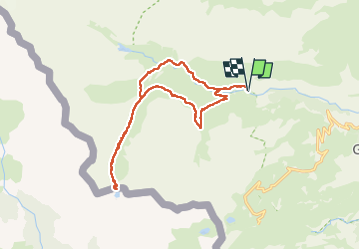

Length
17.1 km

Max alt
2340 m

Uphill gradient
806 m
Km-Effort
28 km

Min alt
1651 m

Downhill gradient
807 m
Boucle
Yes
Creation date :
2022-06-23 10:02:01.0
Updated on :
2022-06-23 18:24:14.064
7h57
Difficulty : Medium

FREE GPS app for hiking
 SityTrail
IGN / Geographical institutes
SityTrail Plus
The world is yours!
About
Trail Walking of 17.1 km to be discovered at Occitania, Hautespyrenees, Gavarnie-Gèdre. This trail is proposed by GOHIER.
Description
Magnifique vallon et découverte d’un lac impressionnant. Dommage météo humide mais belles éclaircies.
Positioning
Country:
France
Region :
Occitania
Department/Province :
Hautespyrenees
Municipality :
Gavarnie-Gèdre
Location:
Gavarnie
Start:(Dec)
Start:(UTM)
741080 ; 4736907 (30T) N.
Comments