


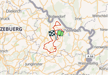
ExtraTourFelsenlandschaft on GPSies.com

kodak
User

Length
43 km

Max alt
398 m

Uphill gradient
795 m
Km-Effort
54 km

Min alt
290 m

Downhill gradient
794 m
Boucle
Yes
Creation date :
2022-06-24 09:32:22.88
Updated on :
2022-06-24 09:33:50.386
0m
Difficulty : Easy

FREE GPS app for hiking
 SityTrail
IGN / Geographical institutes
SityTrail Plus
The world is yours!
About
Trail Cycle of 43 km to be discovered at Unknown, Canton Echternach, Consdorf. This trail is proposed by kodak.
Positioning
Country:
Luxembourg
Region :
Unknown
Department/Province :
Canton Echternach
Municipality :
Consdorf
Location:
Unknown
Start:(Dec)
Start:(UTM)
309600 ; 5517797 (32U) N.
Comments