


Trace G4 Lhez Guy

mitch1952
User
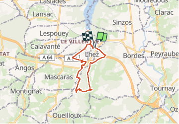

Length
13.7 km

Max alt
445 m

Uphill gradient
289 m
Km-Effort
17.6 km

Min alt
271 m

Downhill gradient
290 m
Boucle
Yes
Creation date :
2022-06-24 07:15:49.0
Updated on :
2022-06-24 12:25:28.944
4h00
Difficulty : Unknown

FREE GPS app for hiking
 SityTrail
IGN / Geographical institutes
SityTrail Plus
The world is yours!
About
Trail Walking of 13.7 km to be discovered at Occitania, Hautespyrenees, Lhez. This trail is proposed by mitch1952.
Positioning
Country:
France
Region :
Occitania
Department/Province :
Hautespyrenees
Municipality :
Lhez
Location:
Unknown
Start:(Dec)
Start:(UTM)
272316 ; 4787318 (31T) N.
Comments