


Col des Especières

GOHIER
User
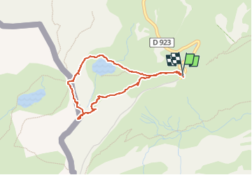

Length
3.6 km

Max alt
2444 m

Uphill gradient
253 m
Km-Effort
7 km

Min alt
2196 m

Downhill gradient
254 m
Boucle
Yes
Creation date :
2022-06-25 10:46:29.0
Updated on :
2022-06-25 14:57:56.667
2h12
Difficulty : Easy

FREE GPS app for hiking
 SityTrail
IGN / Geographical institutes
SityTrail Plus
The world is yours!
About
Trail Walking of 3.6 km to be discovered at Occitania, Hautespyrenees, Gavarnie-Gèdre. This trail is proposed by GOHIER.
Description
Trop de vent.
Positioning
Country:
France
Region :
Occitania
Department/Province :
Hautespyrenees
Municipality :
Gavarnie-Gèdre
Location:
Gavarnie
Start:(Dec)
Start:(UTM)
741494 ; 4733210 (30T) N.
Comments