


Quoeux Haut-Mainil

jpblimond
User
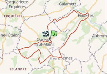

Length
19.9 km

Max alt
140 m

Uphill gradient
218 m
Km-Effort
23 km

Min alt
44 m

Downhill gradient
218 m
Boucle
Yes
Creation date :
2022-06-26 10:53:21.0
Updated on :
2022-07-02 06:29:23.267
4h30
Difficulty : Medium

FREE GPS app for hiking
 SityTrail
IGN / Geographical institutes
SityTrail Plus
The world is yours!
About
Trail Walking of 19.9 km to be discovered at Hauts-de-France, Pas-de-Calais, Quœux-Haut-Maînil. This trail is proposed by jpblimond.
Photos

Positioning
Country:
France
Region :
Hauts-de-France
Department/Province :
Pas-de-Calais
Municipality :
Quœux-Haut-Maînil
Location:
Unknown
Start:(Dec)
Start:(UTM)
437116 ; 5572469 (31U) N.
Comments