


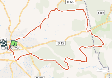
Autour de LAMBESC

didierc13
User

Length
14.5 km

Max alt
298 m

Uphill gradient
198 m
Km-Effort
17.1 km

Min alt
197 m

Downhill gradient
206 m
Boucle
Yes
Creation date :
2022-06-27 04:07:35.0
Updated on :
2022-06-27 07:24:35.602
3h16
Difficulty : Medium

FREE GPS app for hiking
 SityTrail
IGN / Geographical institutes
SityTrail Plus
The world is yours!
About
Trail Walking of 14.5 km to be discovered at Provence-Alpes-Côte d'Azur, Bouches-du-Rhône, Lambesc. This trail is proposed by didierc13.
Description
Vignes lavandes forêts village
Photos


Positioning
Country:
France
Region :
Provence-Alpes-Côte d'Azur
Department/Province :
Bouches-du-Rhône
Municipality :
Lambesc
Location:
Unknown
Start:(Dec)
Start:(UTM)
682386 ; 4835828 (31T) N.
Comments