


Mont Lozère Pont de Montver

darranger
User
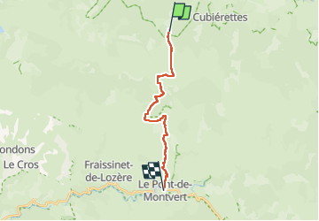

Length
15.9 km

Max alt
1699 m

Uphill gradient
306 m
Km-Effort
22 km

Min alt
875 m

Downhill gradient
842 m
Boucle
No
Creation date :
2022-06-27 06:02:13.005
Updated on :
2022-06-27 13:07:01.936
4h35
Difficulty : Very difficult

FREE GPS app for hiking
 SityTrail
IGN / Geographical institutes
SityTrail Plus
The world is yours!
About
Trail Walking of 15.9 km to be discovered at Occitania, Lozère, Cubières. This trail is proposed by darranger.
Positioning
Country:
France
Region :
Occitania
Department/Province :
Lozère
Municipality :
Cubières
Location:
Unknown
Start:(Dec)
Start:(UTM)
559510 ; 4922350 (31T) N.
Comments