


Cabane d’Alland (Gavarnie)

GOHIER
User
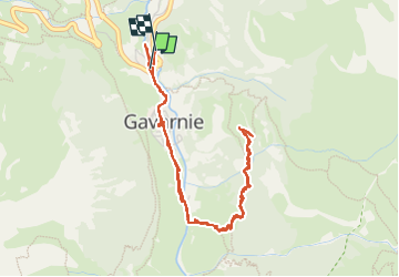

Length
5.6 km

Max alt
1689 m

Uphill gradient
349 m
Km-Effort
10.3 km

Min alt
1351 m

Downhill gradient
352 m
Boucle
Yes
Creation date :
2022-06-27 13:46:39.0
Updated on :
2022-06-27 16:27:18.142
2h39
Difficulty : Very easy

FREE GPS app for hiking
 SityTrail
IGN / Geographical institutes
SityTrail Plus
The world is yours!
About
Trail Walking of 5.6 km to be discovered at Occitania, Hautespyrenees, Gavarnie-Gèdre. This trail is proposed by GOHIER.
Description
Trempés…
Positioning
Country:
France
Region :
Occitania
Department/Province :
Hautespyrenees
Municipality :
Gavarnie-Gèdre
Location:
Gavarnie
Start:(Dec)
Start:(UTM)
744733 ; 4735749 (30T) N.
Comments