


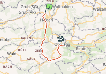
Heiden - St.Anton - Oberegg

steger12
User

Length
8.2 km

Max alt
1111 m

Uphill gradient
361 m
Km-Effort
12.8 km

Min alt
789 m

Downhill gradient
294 m
Boucle
No
Creation date :
2014-12-10 00:00:00.0
Updated on :
2014-12-10 00:00:00.0
--
Difficulty : Unknown

FREE GPS app for hiking
 SityTrail
IGN / Geographical institutes
SityTrail Plus
The world is yours!
About
Trail Other activity of 8.2 km to be discovered at Appenzell Ausserrhoden, Vorderland, Heiden. This trail is proposed by steger12.
Positioning
Country:
Switzerland
Region :
Appenzell Ausserrhoden
Department/Province :
Vorderland
Municipality :
Heiden
Location:
Unknown
Start:(Dec)
Start:(UTM)
540015 ; 5255045 (32T) N.
Comments