


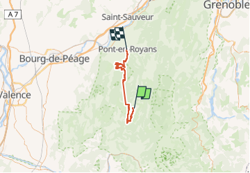
GTV VERCORS J4

nouga
User

Length
47 km

Max alt
1571 m

Uphill gradient
1522 m
Km-Effort
70 km

Min alt
201 m

Downhill gradient
2379 m
Boucle
No
Creation date :
2022-07-01 07:03:58.945
Updated on :
2022-07-01 14:50:55.875
3h47
Difficulty : Very difficult

FREE GPS app for hiking
 SityTrail
IGN / Geographical institutes
SityTrail Plus
The world is yours!
About
Trail Mountain bike of 47 km to be discovered at Auvergne-Rhône-Alpes, Drôme, Vassieux-en-Vercors. This trail is proposed by nouga.
Photos

Positioning
Country:
France
Region :
Auvergne-Rhône-Alpes
Department/Province :
Drôme
Municipality :
Vassieux-en-Vercors
Location:
Unknown
Start:(Dec)
Start:(UTM)
687150 ; 4974067 (31T) N.
Comments