


val clare

JPS73
User
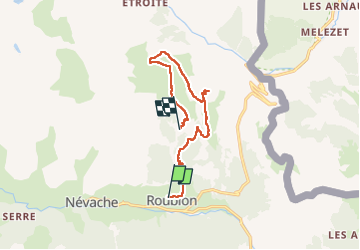

Length
11.5 km

Max alt
2514 m

Uphill gradient
986 m
Km-Effort
24 km

Min alt
1614 m

Downhill gradient
680 m
Boucle
No
Creation date :
2022-07-01 06:33:10.821
Updated on :
2022-07-01 15:26:53.384
3h49
Difficulty : Very difficult

FREE GPS app for hiking
 SityTrail
IGN / Geographical institutes
SityTrail Plus
The world is yours!
About
Trail Walking of 11.5 km to be discovered at Provence-Alpes-Côte d'Azur, Hautes-Alpes, Névache. This trail is proposed by JPS73.
Positioning
Country:
France
Region :
Provence-Alpes-Côte d'Azur
Department/Province :
Hautes-Alpes
Municipality :
Névache
Location:
Unknown
Start:(Dec)
Start:(UTM)
313332 ; 4987902 (32T) N.
Comments