


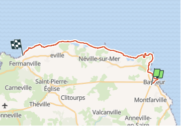
Barfleur-Plage de La Mondrée

JMCMoreau
User


6h00
Difficulty : Easy

FREE GPS app for hiking
 SityTrail
IGN / Geographical institutes
SityTrail Plus
The world is yours!
About
Trail Walking of 19.3 km to be discovered at Normandy, Manche, Barfleur. This trail is proposed by JMCMoreau.
Description
Circuit en ligne avec voitures à l'arrivée sur le parking Aire camping-car, Fréval, 50840 Fermanville
Pas mal de bitume!!
Parcours possible dans les 2 sens.
Distance P/R au gîte: 15 Km/16'
Visiter l'église de St Pierre l'église
Positioning
Comments