


rando binche

brunobuj
User
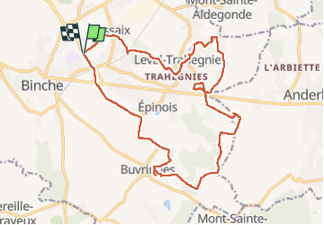

Length
19.9 km

Max alt
210 m

Uphill gradient
218 m
Km-Effort
23 km

Min alt
86 m

Downhill gradient
219 m
Boucle
Yes
Creation date :
2022-07-02 07:47:27.75
Updated on :
2022-07-02 14:45:32.336
5h29
Difficulty : Very difficult

FREE GPS app for hiking
 SityTrail
IGN / Geographical institutes
SityTrail Plus
The world is yours!
About
Trail Walking of 19.9 km to be discovered at Wallonia, Hainaut, Binche. This trail is proposed by brunobuj.
Positioning
Country:
Belgium
Region :
Wallonia
Department/Province :
Hainaut
Municipality :
Binche
Location:
Unknown
Start:(Dec)
Start:(UTM)
583925 ; 5585782 (31U) N.
Comments
Très chouette rando Cependant, 2 points d'attention : A Ressaix, du km 1.9 au km 2.5, "sentier du terril de la Courte" appartient à la région et on ne peut pas passer sans document d'autorisation bien qu'il n'y ait rien qui l'interdise (je me suis fait arrêter par un garde forestier) Au km 10.9, le sentier est mangé par le champs